Grand River Conservation Authority (GRCA) Comments
A portion of Larch Creek, which is a tributary of the Canagagigue Creek, traverses the area north of
Parcels 1 and 3 in a west/east direction. Associated with the creek are wetlands, steep slopes, and
floodplain areas covering approximately half of the Open Space area to the north of Parcel 1 and the
majority of the Open Space area to the north of Parcel 3. These two parcels are regulated by the
Grand River Conservation Authority (GRCA) and development within or in close proximity to these
environmental features is prohibited. Staff met with the GRCA to discuss this, and GRCA Staff
confirmed that there may be opportunity to develop a portion of the area immediately adjacent to the
Unopened Road Allowance ÔÇô shown as Parcel 1 on Map 1 - as this portion would be outside the
regulatory floodline and adequately set back from the wetland area.
A GRCA permit would be required for the portions of Parcels 1 and 3 that are outside the
environmental features but within the buffer area around these features and, therefore are still within
the GRCA regulation limit. There should be no significant GRCA issues with developing the lands
south of the Unopened Road Allowance (Parcels 2 and 4). To evaluate a permit application for
development, the GRCA requires the following:
• a detailed stormwater management report;
• a lot grading and drainage plan;
• survey of the floodline elevation (as the regulatory floodline has been engineered (this survey
must demonstrate that all of the proposed residential lots will be outside the regulatory
floodline);
• verification of the wetland area in the field;
• a discussion of soils and hydrogeology; and,
• establishment of a 30 metre setback from the GRCA's wetland boundary.
Environmental Planner, Region of Waterloo
Staff solicited comments from the Region's Environmental Planner, who indicated that there is
potential for development to occur within the subject lands provided that the value of the woodlot is
maintained or even enhanced through appropriate forest management activities. He believes that the
value of the forest is to provide aquatic and wildlife habitat, microclimate effects (temperature changes
through shading and wind break), and aesthetics for both the surrounding residences and those using
the trails. Prior to undertaking any activity, the Environmental Planner suggested the following:
• Complete a Natural Habitat Inventory to determine how the woodlands are linked with the larger
natural system and to identify potentially sensitive/significant features;
• Develop a long-term management plan to maintain the overall health of the environmental
features, which includes providing suitable buffers and zoning from the creek and implementing
measures to deter encroachment (dumping, building, clearing, etc.); and,
• Undertake an improvement cut of the woodlot to take down poor quality, declining or hazardous
trees. Once the trees are taken down, it may be easier to determine the appropriate lot and
building layout by avoiding areas of high quality or valued trees. If the cutting is completed a least
a year before development occurs, the balance of the woodlot will have time to adapt to the new
conditions.
As recommended by the Region, Staff retained Ecoplans Limited (Environmental Planners) to begin
some of the initiatives that the Region's Environmental Planner suggested by conducting an analysis
of the woodlot and other environmental features to determine:
• the quality of the woodlot (i.e. Provincial, Regional or Local Significance);
• its value as a natural wildlife habitat;
• its current condition; and,
• the conclusions and recommendations that can be formed with respect to the development
potential within or adjacent to this area.
OfficeáofátheáCAOáá
á
7
á
Novemberá3,á2009á
REPORTáA6ÔÇÉ2009á
This evaluation was based on multi-season field surveys of the entire lands owned by the Township,
including the subject lands, correspondence from the Region's Environmental Planner, and application
of relevant policy and guidelines. Ecoplans provided the Township with the final report, Natural
Habitat Inventory / Ecological Evaluation, in August of 2007 and the following is a summary of their
observations, conclusions, and recommendations.
Ecoplans completed a three-season (spring, summer and fall) vegetation/wildlife inventory and
assessment of the subject lands and surrounding lands in August, September and November of 2006
and May, June, and July of 2007. This assessment was completed in the context of the current
planning policy (Provincial Policy, Regional Official Policies Plan, Township Official Plan and GRCA
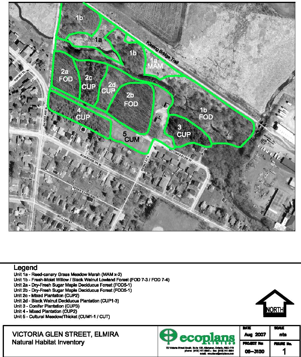
regulations). The site was divided into the following five principal habitat blocks (illustrated on the
following Figure):
• Unit 1a and 1b: the riparian zone along the creek at north end of Parcels 1 and 3. The lands
contain the floodplain area, open meadow marsh (Unit 1a) and a band of lowland deciduous forest
(Unit 1b) along the creek.
• Unit 2a: is a primarily a dry-fresh, closed canopy of mid-aged sugar maple forest/plantation
adjacent to Snyder Avenue with occasional to rare, of other species such as Basswood, Common
Hackberry, American Beech and White Ash.
• Unit 2b: is primarily a dry-fresh, closed canopy of young to mid-aged sugar maple forest/plantation
adjacent to the open cultural meadow. This area has low diversity of other species but contains
several large mature Black Walnuts.
• Unit 2c: this central area includes mixed conifers and deciduous plantations. The partially closed
canopy is mixed of immature to sub-mature trees including White Pine, Norway Spruce and Black
Walnut with occasional Sugar Maple. Regeneration is occurring of White Ash, Norway Maple,
Sugar Maple, Manitoba Maple and some Choke Cherry.
• Unit 2d: a smaller plantation of trees dominated by young Black Walnut closed canopy and some
White Ash.
• Unit 3: this area is a conifer plantation with natural regeneration, characterized by partially closed
canopy of mid-aged Scots Pine and Norway Spruce, with White Ash, Black Walnut and Manitoba
Maple. Blow down is abundant in this area.
• Unit 4: this block is a mid-aged to sub-mature mixed plantation containing closed canopy of aged
Scots Pine and Norway Spruce and Black Walnut with associated White Ash, Tamarack and Sugar
Maple.
• Unit 5: this area comprises of maintained turf grass and cultural habitats along the unopened road
allowance and well site.

Officeáofátheá
the CAOáá
á
8
á
Novemberá
November 3,á2009á
REPORTáA6ÔÇÉ2009
ÔÇÉ
á
FIGURE 1: Principle Habitat Blocks
C:\DOCUMENTS AND SET
S
TING
I
S\BEVERLY\LO
S\BEVERLY
CAL SETTING
I
S\T
NG
EMPO
E
RARY INT
ARY
ERNET
E
FILES\O
I
LK95\REPORT.DOC
OfficeáofátheáCAOáá
á
9
á
Novemberá3,á2009á
REPORTáA6ÔÇÉ2009á
The following are Ecoplans' observations and conclusions based on their fieldwork and review of
relevant policy:
• No records of endangered species or threatened species.
• No Federally or Provincially designated rare species-at-risk or provincially rare species observed.
• The creek corridor forms a local east-west linkage, providing an opportunity for wildlife movement.
The wooded area provides a supplemental habitat, but since it is bounded by residential
development it has limited function as ecological linkage/wildlife movement areas.
• No significant wildlife habitat present on the lands.
• No record that the wetland on the property is provincially significant or has been evaluated by
MNR.
• The property contains a watercourse, associated floodplain and steep slopes that are regulated by
the GRCA. The Township should consult the GRCA to determine an appropriate setback of any
development adjacent to the wetland and floodplain areas.
• The woodland on site would likely not be considered Provincially Significant under their criteria.
• The Region has not designated all or portion of the site as an Environmentally Sensitive Policy
Area (ESPA).
• A portion of the woodland, primarily within the environmental features adjacent to the Creek (Units
1a and 1b), does display characteristics of a Locally Significant Natural Area (LSNA). The
Township should avoid significant encroachment into the LSNA limits. The general limit of the
LSNA is coincident with the south limit of Unit 1b.
In considering the ecological significance and sensitivity of the woodland features on site and relevant
policy, Ecoplans recommends the following:
• No development potential in Unit 1a or 1b because of the existing environmental features
(wetland, creek, floodplain, etc.) which display characteristics of a Locally Significant Natural Area
(LSNA).
• Some development potential in Unit 2 (a-d) outside the floodplain area because the woodland
generally includes several cultural vegetation features of relatively low ecological significance.
Some of the planted Sugar Maples have naturally regenerated and are in moderately good health.
As a result, the area does offer some ecological function in terms of diversity of wildlife and native
plant species. Rear lot easements are recommended.
• Unit 3 has limited potential due to the floodplain. The area has been disturbed and displays low
ecological significance.
• Unit 4 and 5 have the greatest development potential because of disturbance to the area, low
ecological significance, and location outside the floodplain area.
• To consult with the GRCA to delineate the wetland and floodplain area and determine the
appropriate setbacks to the various features (with buffer management recommendations).
• Develop a long term management plan strategy for the retained woodlot in Unit 2.
• Carry out an improvement cut of the woodland in Unit 2 as recommended by the Region.
• Refine the development concepts to reflect the natural environmental recommendations with input
from the review agencies.
In summary, based on work done by Ecoplans, comments from the Regional Environmental Planner,
and the GRCA's review of the Ecoplans report, there appears to be no significant environmental
constraints that preclude some forms of residential development on the subject lands as identified on
Map 1. Development in these areas may require shallower lots to maintain an appropriate setback to
the environmental features, as well as wider lots to maximize tree retention. Other mechanisms to
ensure conservation of the natural features and tree retention include but are not limited to: tree
saving plans, erection of monuments, conservation easements, and restriction of rear yard
development. If Council decides to proceed with residential development on the subject lands, a
program should be established to implement Ecoplans' other recommendations.
OfficeáofátheáCAOáá
á
10
á
Novemberá3,á2009á
REPORTáA6ÔÇÉ2009á
Ecoplans' full report is on the Township of Woolwich website ÔÇô www.woolwich.ca ÔÇô and also available
for review at the Township Administration Building at the Planning Counter (1st floor) and the CAO
Counter (2nd floor).
In terms of the wooded areas on the subject lands, the Region's Environmental Planner indicated that
there is potential for residential development to occur within the existing woodlot provided that the
value of the woodlot is maintained or enhanced through appropriate forest management activities.
Both the Region's Environmental Planner and Ecoplans suggest that the Township should undertake
an improvement cut of the woodlot to remove poor quality, declining, or hazardous trees regardless of
whether development occurs on the lands. The cost to complete the improvement cut in the woodlot
is approximately $2000 ($500 to mark the trees and $500-$1500 to oversee the cut). Revenues
received from the sale of the trees for firewood could offset this expense. Staff believes that removing
a portion of the trees from the subject lands can be completed in a way to have a negligible impact to
the surrounding area through use of tools already mentioned in this section and continued by groups
such as TWEEC. Staff recommends allocating funds to TWEEC for reforestation, tree planting, and/or
other environmental rehabilitation projects within the Township.
In conclusion, the proposed residential development on the subject lands conform to the policies in the
Township's Official Plan and the Region's Official Plan (ROP). In addition, based on research by
Ecoplans and consultation with the GRCA and Region, the subject lands do not contain significant
natural features that would preclude residential development. In addition, through the normal
development process, consultation with agencies such as the GRCA will ensure that appropriate
measures will be put into place to protect and conserve surrounding features.
3.3 Other Technical Issues
Amount of Parkland and Open Space
Members of the public commented that development of the subject lands will reduce the amount of
open space available for use by the public. At the June 23, 2009 Public Meeting and in
correspondence, members of the public have expressed concern about this for a variety of reasons
(including environmental, recreational, spiritual, and educational), and stated that there are limited
opportunities for the public to access open space and parkland in Elmira and the Township of
Woolwich.
• Staff Comments: Preliminary development options illustrate that the current amount of
land used as parkland and open space could be reduced by 1.03 hectares (2.55 acres),
which is 20.6% percent of the overall area owned by the Township. This amount might
actually be less due to tree conservation plans, and new features designed to enhance and
connect open space. In addition, preliminary development options illustrate that lands
immediately north of the subject lands and connections to the Kissing Bridge Trailway
would be maintained as Open Space, if not enhanced.
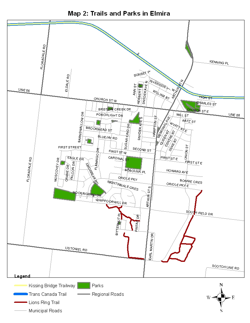
In terms of opportunity and access to open space and parkland in Elmira and Woolwich
Township, Map 2 illustrates the public parks and trails within proximity to the subject lands.
Map 3 illustrates public access points to the Kissing Bridge Trailway.

Officeáofátheá
the CAOáá
á
11
á
Novemberá
November 3,á2009á
REPORTáA6ÔÇÉ2009
ÔÇÉ
á
C:\DO
:\DO
C
CUMENTS AND SET
S
TING
I
S\BEVERLY\LO
S\BEVERLY
CAL SETTING
I
S\T
NG
EMPO
E
RARY
R
INT
ARY
ERNET
E
FILES\O
I
LK95\REPORT.DOC
C

OfficeáofátheáCAOáá
á
12
á
Novemberá3,á2009á
REPORTáA6ÔÇÉ2009á
OfficeáofátheáCAOáá
á
13
á
Novemberá3,á2009á
REPORTáA6ÔÇÉ2009á
Sanitary Sewer Capacity
• Staff Comments: In 2006, Stantec completed a servicing study for the Township which
included a review of the existing system as it pertains to the Lunor development, the subject
lands, and the industrial lands to the east. It was concluded that the current sanitary system
can accommodate residential development on the subject lands.
Replacement of the sanitary sewer within the unopened road allowance would not be triggered
by development on the subject lands; however, the sewer will have to be upgraded for the
Lunor residential development. Therefore, the unopened road allowance through the
subject lands will ultimately be disturbed, regardless whether the development occurs
on the subject lands.
Storm Water Management (volume and quality)
Citizens expressed concerns that storm water currently flows directly into Larch Creek from the storm
pipe at the end of Dunke Avenue, and that the addition of residential units and removal of trees and
vegetation would negatively affect the water quality in the creek and increase the risk of flooding.
• Staff Comments: While development on the subject lands would increase the amount of hard
surfaces, decrease permeability, reduce the amount of vegetation on the subject lands, and
result in an increased amount of runoff into the water system (with greater amounts of
sediment and increased temperatures), there are ways to manage these issues.
In the mid-1980s, storm water management ponds started to be incorporated into residential
developments as a method of managing the volume of storm water. Now, storm water
management ponds are utilized to manage both volume and quality of water. Installing a storm
water management pond in the general vicinity of the subject lands is not likely necessary as
the scale of the proposed development would not warrant this approach. For this scale of
residential development, an oil-grit separator could be incorporated into the new road to
manage water quality. In addition, forms of quality control can also be installed at the end of
the storm pipe on Dunke Avenue. Staff suggests that conservation easements for the
backyards of residential lots are also considered as a method of managing storm water quality
and quantity.
Through the development process, a number of studies will be completed to inform the
detailed design of the residential development. For example, a Groundwater Monitoring
Program will be undertaken to evaluate the ground water and how it relates to development of
the subject lands. In addition, a Storm Water Management Plan is required, which will be
reviewed by Township Engineering and GRCA Staff. The information developed through all
studies will result in specifications that will be incorporated into a detailed design, allowing Staff
to evaluation options. This process will ensure that issues including water flow, water quality,
drainage, erosion, flooding, and access are addressed.
Regional Land (Parcels 4 and 5)
The Region of Waterloo currently own Parcels 4 and 5. The Township is exploring the purchase of
these parcels.
• Staff Comments: Staff recommends that the final sale of the Regional lands to the Township
is conditional on:
• standard conditions applying to any Purchase & Sale Agreement;
• that the Purchase & Sale Agreement is reviewed by the Township Solicitor; and,
• Council passes a By-law authorizing the Mayor and Clerk to sign the Agreement.
If the Township does not secure the Regional lands but the Township-owned land is developed
and the road is built, provisions can be made to secure future residential development on the
OfficeáofátheáCAOáá
á
14
á
Novemberá3,á2009á
REPORTáA6ÔÇÉ2009á
Regional lands and recoup expenses for the construction of roads and services by taking a 1-
foot reserve. Therefore, if a private party develops the land in the future, they will have to
compensate for the appropriate share of roads and services.
Although we are in negotiations, the purchase of the Regional lands will not be pursued if
Township Council chooses to not pursue development of the subject lands.
Water Service
• Staff Comments: A 150mm (6ÔÇØ) water line would be installed into the road allowance to
provide potable water to the development. There are no issues with installing this
infrastructure.
Road Connections
Members of the public expressed concern that the addition of new residential units to the general area
will slightly increase the amount of vehicular traffic on the adjacent roads, creating safety and volume
issues for drivers and pedestrians.
• Staff Comments: The Township's Official Plan promotes the modified-grid road pattern where
appropriate and connections to existing roads. The subject lands contain an existing unopened
road allowance that provides opportunity for a logical extension of Victoria Glen Street (from
Dunke Street to Snyder Avenue). The new road would be consistent and compatible with the
current modified-grid road pattern in the neighbourhood. As with all residential development,
appropriate and safe design for vehicular, pedestrian, and bicycle traffic would be engineered
and a functional design would be developed. In terms of traffic volume, the surrounding roads
are designed to accommodate traffic and the addition of 25-30 residential units is well within
the design capacity of the roads. Engineering Staff commented that a Traffic Study is not
warranted for small developments like this.
The unopened road allowance is 12.2 meters (40 feet) in width, which is similar to a portion of
Victoria Glen Road. For any type of residential development other than a condominium, a road
would have to be developed, which would be a cost to the Township. Engineering Staff noted
that the existing road allowance is substandard and would be brought into conformity with
typical road cross-sections.
Staff will look specifically at the connections of the subject lands to Snyder Avenue, and other
key areas as identified. With respect to the Playford Farm, the only issue that will be
addressed by Township Staff in terms of road connections and access will be the connection
to Snyder Avenue.
Encroachment
Small sheds, gardens, lawns, and other land uses associate with adjacent properties are encroaching
onto Township and Regional lands.
• Staff Comments: Staff suggests that these encroachments be addressed prior to
development of the subject lands. Staff also suggests that education about encroachment is
part of addressing this issue.
OfficeáofátheáCAOáá
á
15
á
Novemberá3,á2009á
REPORTáA6ÔÇÉ2009á
Kissing Bridge Trailway
Members of the public have questioned whether or not development will remove and/or change the
Kissing Bridge Trailway.
• Staff Comments: There is no intention to remove the Kissing Bridge Trailway or remove
public access points to the Kissing Bridge Trailway in the vicinity of the subject lands. Public
Trails in Woolwich, including the Kissing Bridge Trailway, are important aspects of the
Township and Staff is committed to maintaining these resources.
Township of Woolwich Environmental Enhancement Committee (TWEEC)
Clarification of the role of Township of Woolwich Environmental Enhancement Committee (TWEEC)
with respect to the subject lands was requested.
• Staff Comments: TWEEC is a Committee of Council and set up as an operations group to
complete projects throughout the Township. TWEEC was not intended or set up to provide
comments on planning applications.
3.4 Summary of Evaluation of Policy and Technical Issues
In conclusion, based on consultation with Township Staff, research and study by Ecoplans, the
Region, and consultation with the GRCA, development of the subject lands for residential uses is
technically feasible subject to completing additional studies identified through this report as well as the
detailed design and engineering of the development. Notwithstanding this, there is another key issue
requiring discussion: the issue of the benefits of developing the subject lands versus retaining the
subject lands as open space.
4.0 BENEFITS OF DEVELOPING THE SUBJECT LANDS VERSUS
RETAINING THE SUBJECT LANDS AS OPEN SPACE
Staff considered whether the subject lands should be retained as part of the overall area and not
developed. This issue was clearly articulated by members of the public. Staff received comments
indicating that developing the subject lands is not required and inconsistent with the Township's
policies. Furthermore, members of the public stated that the subject lands should be preserved as
they are for aesthetic, recreational, educational, and spiritual uses (i.e. not developed for residential
uses).
If the Township does not explore development of the subject lands, the subject lands could be
preserved. In this scenario, the Township would not receive anticipated revenues for the Capital
Facilities Program. The financial implications of not pursuing development of the subject lands are
outlined in the following section, Section 5.0.
Conversely, all vegetation on the subject lands could be removed and cut down to maximize
development potential. This would allow for a greater number of smaller lots but no tree retention. In
this scenario, the Township could receive anticipated revenues for the Capital Facilities Program.
A third option is to design a balanced approach which would entail larger lots and greater tree
conservation and protection on the subject lands. Although Staff have received questions and
comments about the proposed development of the subject lands in relation to the Township's
Environmental and Stewardship Policies, Staff believe that the Township has implemented this
balanced approach in the past with success. There are at least two developments that have occurred
within woodlots: South Parkwood residential development, and the Walmart commercial development.
In both cases, the integrity and functioning of the woodlots have not been compromised. In addition,
in both instances, the majority of land has been retained as Open Space, thereby protecting land in
perpetuity that would otherwise be developed and not protected.
OfficeáofátheáCAOáá
á
16
á
Novemberá3,á2009á
REPORTáA6ÔÇÉ2009á
if Council proceeds to develop the lands, Staff will look at a variety of options, including a lotting
scheme that provides greater exposure and access to the wooded area north of the unopened road
allowance. The Township could consider the feasibility of not developing a certain number of lots
north of the unopened road allowance to provide greater exposure and accessibility to the woodlot.
It is important to recognize that the Township has been actively accumulating open space where
possible, and effectively using the development approval process to secure, conserve, and protect
open space and environmentally sensitive areas. Over the past 20 years, approximately 149.71
hectares (370 acres) has been accumulated and secured as open space for the Township through the
development approval process in Breslau, Elmira, and St. Jacobs.
5.0 FINANCIAL SUMMARY
Through the Capital Facilities Program, Staff is anticipating allocating a portion of the sale of assets in
the amount of approximately $1.93 million. Of this amount, $1.5 million was to be realized from the
development of the Victoria Glen lands. Although the Township may not require all of the funds
received from the development of the Victoria Glen lands for the Capital Facilities Program, the
additional revenue will be required to aid in funding the 5-year Capital Forecast. Also, any additional
revenue will be used to offset costly hard infrastructure projects that may be impacted by the outcome
of infrastructure review studies.
The detailed financial implications of proceeding with declaring the subject lands surplus and
developing them for residential uses could potentially net the Township approximately $1.93 million if
the Regional lands are acquired, and approximately $1.29 million without the Regional lands as part of
the development.
If Council chooses not to proceed with declaring the subject lands surplus and developing the Victoria
Glen lands, the monies anticipated will have to come from another source. Staff has identified a few
options for securing the necessary funding in substitute of the potential proceeds from the Victoria
Glen Lands, as follows:
Use of Long-term Borrowing / Debenture
Recently through report F22-2009, Council approved the long-term borrowing of $3.72 million as part
of the overall financing of the Capital Facilities Program. This amounts to approximately $181 per
capita for the Township of Woolwich. Through report F18-2009 (Capital Budget Forecast 2010-2013),
Council amended the debenture maximum per capita from $190 to $230. If Council were to replace
the funds anticipated from the development of the Victoria Glen Lands with a long-term borrowing
option, this would create an additional 1.7% burden in the 2010 levy requirement.1 For Council's
information, a 1.7% increase would impact the average residential tax bill in the Township by an
additional $9.73. It would also increase the existing debt per capita to $254, which would mean that
Council will need to further amend the maximum debt per capita. In addition, depending on Council's
debt threshold, this may jeopardize the Township's Five-year Capital Forecast as the plan is based on
modest debenture amounts. This could result in deferring or possibly cancelling planned capital
projects such as roads and bridges.
Use of Proceeds from the Sale of Other Surplus Lands / Properties
As Council is aware, through report E75-2009 a number of lands and properties were declared
surplus. Through the disposal of these properties the Township could realize up to approximately
$1.2 million in additional revenue. There are a number of inherent dangers with using this option in
replace of the proceeds from Victoria Glen. For example, the Township may not be able to sell these
properties for a number of years and when these properties are sold, the final number may fall
1 $1.5 million debenture for 25 years at 5%-6% generates an annual repayment of approximately $107,000.
OfficeáofátheáCAOáá
á
17
á
Novemberá3,á2009á
REPORTáA6ÔÇÉ2009á
significantly short of the projected amount. As well, the proceeds from the sale of the properties and
lands could be used as a source of funding to aid in the replacement of potentially costly hard
infrastructure (i.e. roads and bridges).
Use of Reserve and Reserve Funds
This issue has been raised in other situations in the Township and Staff's opposition to this approach
remains the same ÔÇô this goes against the fundamental purpose of establishing Reserve and Reserve
Funds and Staff does not recommend this approach. The fundamental problem with this alternative is
the ÔÇ£stealing from Paul and giving to PeterÔÇØ scenario. If we were to take funds from Reserve and
Reserve Funds, we would in essence endanger the activities that these Reserve and Reserve Funds
were specifically set up to achieve. If Council is willing to entertain this option, a full evaluation and
discussion will need to occur to determine the activities that would need to be deferred or cancelled.
6.0 CONCLUSION AND RECOMMENDATIONS
6.1 Conclusions
Staff has concluded that the Township should continue to explore the options for residential
development on the subject lands based on the following reasons:
• Development can be achieved outside of significant environmental features: Based on
research and consultation by Ecoplans, the GRCA, and the Region, there is sufficient land
adjacent to the unopened road allowance and outside of the significant environment
constraints regulated by the GRCA for residential development. In addition, a GRCA permit
would be required for development as well as a detailed stormwater management report, a lot
grading and drainage plan, and a survey of the regulatory floodline to demonstrate all
proposed residential lots are located outside of the regulated floodline. These requirements
will ensure that proper process is followed and appropriate measures are implemented to
protect and conserve environmental features of the surrounding area.
• Conformity with Township Planning Framework: The current Official Plan and Zoning By-
law provides for some form and scale of residential development on a portion of the subject
lands, and there are no technical reasons preventing the subject lands from being developed
for residential purposes and in accordance with good planning, environmental, fiscal, and
design principles.
• Conformity and Support for Provincial and Regional Planning Goals: This development
would go towards meeting Woolwich's intensification targets within the existing built-up area as
prescribed in the ROP and Provincial Growth Plan.
• Sufficient Servicing Capacity: The subject lands contain an existing unopened road
allowance with services that provide a natural and logical extension of the residential
neighbourhood and street pattern. In addition, there is sufficient sanitary service capacity to
accommodate residential development, without upgrading the existing sewer within the
unopened road allowance.
• Fiscal Responsibility: There is the potential to generate a significant net surplus given the
estimated revenues and costs for each development option which would contribute to the
Township Capital Projects Fund and future Capital Projects.
• Balance: The members of the public who attended the June 23, 2009 Public Meeting and
submitted comments were virtually unanimous in their desire to see the subject lands
preserved as they are for aesthetic, recreational, educational, and spiritual purposes. Staff
believes that since the subject lands comprise a small part of the overall area, these activities
can still be accommodated while also enabling the municipality in balance, to achieve other
important objectives relating to financing important capital projects.
OfficeáofátheáCAOáá
á
18
á
Novemberá3,á2009á
REPORTáA6ÔÇÉ2009á
6.2 Recommendations
Staff recommends that the Council of the Township of Woolwich proceed with declaring the subject
lands surplus and exploring the development of the subject lands for residential purposes in
accordance with the following key principles:
1. Develop an appropriate number of residential lots on the Township-owned lands (Parcels 1, 2,
3) and lands currently owned by the Region (Parcels 4 and 5) as appropriate to the existing
urban form and densities in the surrounding area.
2. Provide for accessible, safe, and well-designed public access throughout the development
area, including connections to the surrounding area.
3. Implement enhancements to pedestrian access points to the Kissing Bridge Trailway to
improve the experience for trail users, including consideration of a public access through the
subject lands to the Kissing Bridge Trailway.
4. Manage any encroachment on the subject lands associated with adjacent properties.
5. Be sensitive to the needs and potential impact(s) on the surrounding area, and ensure that
appropriate measures are taken to mitigate the impact of residential development on the
surrounding area.
6. Conform to the policies in the Township of Woolwich Official Plan, including Environmental and
Stewardship policies.
7. Ensure that any residential development and associated infrastructure is: outside of the
regulatory floodline, wetland, steep slopes, and other features regulated by the GRCA; and,
outside of the Locally Significant Natural Areas as identified by Ecoplans.
8. Conduct an improvement cut of the woodlot in accordance with good ecological principles.
9. Provide for the protection and conservation of trees where possible.
10. Balance environmental protection and conservation with providing sufficient funds for
Township of Woolwich Capital Projects.
11. Ensure that appropriate reforestation, tree planting, and/or other environmental rehabilitation
projects within the general area of the subject lands are implemented in conjunction with the
development of the subject lands, and in accordance with good ecological principles.
12. Ensure that development does not adversely impact the existing infrastructure and services in
Elmira.
7.0 NEXT STEPS
If development of the subject lands is to be pursued, the following steps will be undertaken by
Township Staff:
• continue negotiations with the Regional Municipality of Waterloo for the purchase of the Region-
owned lands and successfully negotiate a Purchase & Sale Agreement; and,
• engage necessary services to complete required studies to determine the appropriate
development option.
Staff will report back to the Council of the Township of Woolwich with a full analysis, preferred
development option, and work plan with a target date of Fall 2010.
If the Council of the Township of Woolwich does not proceed with declaring the subject lands surplus
and proceeding with development of the subject lands for residential purposes, Staff recommends that
Council direct Staff to review the land use designation of the subject lands as part of the Township of
Woolwich Official Plan Review.
OfficeáofátheáCAOáá
á
19
á
Novemberá3,á2009á
REPORTáA6ÔÇÉ2009á
LIST OF APPENDICES
Appendix 1:
Excerpt of the Minutes from the June 23, 2009 Township of Woolwich Public
Meeting
LIST OF FIGURES
Figure 1:
Principle Habitat Blocks
LIST OF MAPS
Map 1:
Subject Lands
Map 2:
Trails and Parks in Elmira
Map 3:
Pedestrian Access Points to the Kissing Bridge Trailway within the vicinity of the
Subject Lands
OfficeáofátheáCAOáá
á
20
á
Novemberá3,á2009á
REPORTáA6ÔÇÉ2009á
Appendix 1:
Excerpt from Township of Woolwich Committee of the Whole Minutes June 23, 2009
The Committee of the Whole met on the above date in Closed Session commencing at 6:00 p.m. for
regular session. Present: Mayor Strauss, Councillors Bauman, Martin and Weber. Councillor Weber
chaired the meeting.
DISCLOSURES OF PECUNIARY INTEREST
None.
A03-2009: Public Information Report: Review of Victoria Glen Lands
Laurel Davies Snyder, Economic Development & Tourism Officer addressed Council and members of
the public stating that the public meeting to discuss surplus property is not required under the
Planning Act but was scheduled to determine public interest in the property.
Ms. Snyder provided some background information about the property which encompasses 3 parcels
owned by the Township for a total of 1.03 hectares or 20% of the total area of the Glen. A description
of the land was given stating its use for hiking, walking and education the area is also connected to
the Kissing Bridge Tail. Parcel 1 is located to the north of the unopened road allowance (1.58 acres),
Parcel 2 is located to the south side of the unopened road allowance (0.94 acres) and Parcel 3 is
located adjacent to Regional lands and total 0.03 acres. Parcel 1 and 2 and the unopened road
allowance are zoned Residential ÔÇô One Unit Medium Density (R-2A) and Parcel 3 is designated
Residential ÔÇô Mixed Medium Density (R-4).
Ms. Snyder outlined the issues identified to date including; adjacent parcels owned by the Region, the
connection to the Kissing Bridge Trail, environmental features and the unopened road allowance. Ms.
Snyder explained the 5 concepts that were developed to generate discussion, obtain input and identify
key issues. A Notice of Public Meeting was circulated to homeowners with 150 meters of the subject
lands on May 26, 2009, on May 30th the Notice was posted in Community Page, and June 1st it was
posted to the website. Next staff will analyze the issues presented, determine the viability and
appropriateness of proceeding with declaring the lands surplus and bring forward a recommendation
report for Council's approval.
Councillor Weber thanked the audience for attending the meeting and called the first delegation.
Ken Reger: Ken Reger, Elmira presented a letter from Mary Lou McKee, stating her objection to
declaring the lands surplus. The park was established as a reservoir park in 1914, which grew into a
natural forest area. Mr. Reger reported that the park is used as an educational resource by teachers at
Riverside School. He expressed his concern that if the park were altered this would affect the birds
and wildlife in the park. Mr. Reger asked that Council redesignate Victoria Glen as parkland.
Cheryl Fisher: Cheryl Fisher spoke to the history of Victoria Glen Park, also known as Reservoir
Park, stating that the 8 acre tract of land was first purchased from Menno Snyder for $2000 by public
vote in 1914. In 1948 the area was rezoning residential at a time when there was a severe housing
shortage in Elmira at the end of the war. Ms. Fisher stated that in 1947 the local Board of Trade and
Public Utilities Commission and citizens cleaned up the park, to have it re-established parkland,
however the area was rezoned in 1948 under By-law 805. Ms. Fisher reported that as other streets in
the area were developed including William Street, Sunset Place and Snyder Avenue North, Victoria
Glen remained. In 2002 when the Zoning By-law was reviewed the land's designate remained
residential. Ms. Fisher asked Council to designate the area parkland. She stated that Victoria Glen is
advertized second on the Township website under parks. She thanked Council for their dedication
OfficeáofátheáCAOáá
á
21
á
Novemberá3,á2009á
REPORTáA6ÔÇÉ2009á
towards the Township of Woolwich Environmental Enhancement Committee (TWEEC) and asked that
they preserve Victoria Park.
Bert Menkveld: Burt Menkveld, Elmira, reported that he walks in Victoria Glen daily and enjoys the
naturalness of the bush. He stated that he has the lowest house in Elmira and when the creek is high
his sump pump works overtime. He stated that this will be the same for the new development and
many units will have water in their basement. He asked that Council consider Victoria Glen green
space not for the dollar value but for the environmental value.
Christa Mercey: Christa Mercey, Kitchener, a former resident of Elmira stated that she received her
great respect for nature from Victoria Glen park. She uses the park to exercise and find serenity
stating that it connects users with nature and promotes mental health.
Ruth Josephs: Ruth Josephs, Elmira, expressed her appreciation with the park, and asked that it be
preserved.
Karen Orr: Karen Orr, Elmira, commented that her family was looking for green space and was
informed that Victoria Glen Park was a protected park so she moved to Elmira. Victoria Glen Park, on
her option, is selling feature for new residents, as it draws people near. She reported that there are
900 houses being built on Church Street and the park could be used to entice people, and offer a
close natural habitat, that connects them to trails. She asked that Council preserve the natural habitat
as it costs nothing to maintain. She cited a petition she collected with signatures from Elmira but also
Kitchener, Waterloo, Cambridge, Wallenstein, Wellesley from people who use the park regularly. She
would like rezoned protective parkland.
DJ Carroll: D J Carroll, expressed his thanks to Council for working with service groups and citizens
to build, encourage and promote environment. He stated that residents are passionate about Victoria
Park and want to work with Council to preserve it.
John Millar: John Millar, Elmira, commented that he has a background in urban forestry, defined as
the ÔÇÿcareful care and management of urban settings for improving the urban environment'. He
commented that destroying trees and parks is not having care for the environment. He reported that
there are many species of wildlife and trees in the area and that Council preserve the park for children
and future generations.
Susan Bryant: Susan Bryant, Elmira, gave a presentation to Council and members of the public on
the important of water in Victoria Glen Park. She reported that the trees in the area comprise a
Riparian forest which helps with water runoff, erosion control, water table control. Ms. Bryant stated
that the location of the Parcels to be developed are on a slope with the stream at the base, which if
developed would precipitate more runoff water, and dirty water running directly into the stream. The
mature forests in the park provide a natural buffer for the creek and acts as a filter. Ms. Bryant
reported that alternative engineered filters will not be effective, as there is no room for a storm water
pond. She also addressed the potential for flooding. Ms. Bryant addressed Council's support for Clean
Waterways, CPAC, TWEEC, and asked that the resdesignate the land parkland to preserve the water
source.
Merri-Lee Metzger: Merri-Lee Metzger, a teacher at Riverside Public School commented that
preserving Victoria Park gives Council and residents the opportunity to show children that the natural
world should be valued not destroyed. Riverside Public School uses the space as an educational tool
for children to teach them about the environment. Ms. Metzger asked that Council designate the area
as parkland. Ms. Metzger than displayed a slideshow of elementary school children enjoying the park.
OfficeáofátheáCAOáá
á
22
á
Novemberá3,á2009á
REPORTáA6ÔÇÉ2009á
Jeff Seddon: Jeff Seddon, Elmira, thanked Councillor Bauman and Shantz for meeting with him to
discuss the surplus property. Mr. Seddon disagreed with the term ÔÇÿsurplus' property as it refers to open
and green space. Mr. Seddon questioned if due process was followed in 1948 when the area was
rezoned from open space to residential. He asked that Council consider Ms. Metzger's slideshow and
the importance and emotional attachment that residents feel for the park.
Mr. Seddon spoke to other municipalities that are trying to conserve and buy back open space and
beaches that were privatized, remarking that the Township, on the other hand, is trying to sell the
open space they own. He reported that no studies have been done on the park to determine what
effects removing some of the trees will have on the overall forest. Mr. Seddon asked that the
residential zoning be removed.
Henry Edwards: Henry Edwards, Elmira reported that he prefers the trees. Mr. Edwards spoke to
changes in the town, and houses that were torn down to make way for parking lots. The Larch trees in
the park, though they are not a shade tree or ornamental, if torn down, like the houses would not be
returning any time soon. He asked that Victoria Glen and trees remain.
Ryan Orr: Ryan Orr, Elmira, a teenage resident, commented that he enjoys living in Elmira, and its
small town community feel. In particular he enjoys the parks and woodlots the most. He asked that
Council secure the woodlots and trails and push for more of these features.
Todd Cowan: Todd Cowan addressed Council and asked why no potential developers have not
attended the meeting to speak about developing the area. Mr. Cowan reported that with 900 houses
being built on Church Street why do the trees in Victoria Glen have to be destroyed. He asked that
Council make this a priority, rezone the area, and protect it.
Joan Coutu: Joan Coutu, a Planning Professor at the University of Waterloo asked how destroying
the trees in the area conform to the land use paradigm.
Tanya Berner: Tanya Berner, a property owner near the area reported that her side yard runs into
Parcel 3, and asked where is the extra run-off water is going to go? She does not want her yard
flooded with run-off water.
Shawn Playford: Shawn Playford, owns a farm at the end of Snyder Avenue, he asked what
changes in grade will be expected if the land is developed. Any changes to the grade will affect the
crops on the farm. Mr. Playford also spoke to the unopened road allowance remarking that if the road
is changed at all this may affect if he can get crops off his property, as he uses and stores his tractors
and trucks close to the allowance. Mr. Playford also addressed potential flooding from Larch Creek.
Document Outline
- ■
- ■
- ■